


All Products
-
Cell Phone Signal Jammer
-
Portable Cell Phone Jammer
-
Drone UAV Jammer
-
Drone Detector
-
GPS Spoofer
-
High Power Jammer
-
GPS Signal Jammer
-
Remote Control Jammer
-
Audio Recording Jammer
-
5G Jammer
-
Signal Detection Analysis
-
Wireless Communication Network
-
Power Amplifier Module
-
Communications Accessories
-
Starlink Detection & Blocking System
-
 Lance-Canadafast shipping and no problems
-
Lucila-BrazilEquipment of good quality, very responsible seller and fast delivery. I recommend to all Alibaba community / AliExpress. I will definitely buy more units.
-
Hamadivo-FranceBest seller,good transaction and fast delivery time
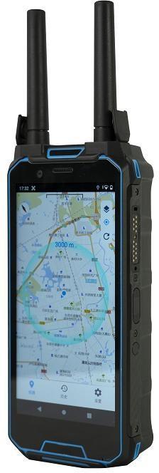
H2L Handheld UAV Detection Localisation Device 6 Inch Map Display Pilot Positioning 580g
| Place of Origin | Shenzhen, China |
|---|---|
| Brand Name | EST |
| Certification | CE & RoHS |
| Model Number | H2L |
| Minimum Order Quantity | 1 Piece |
| Price | USD 3099-4399 / Piece |
| Packaging Details | Protective case 335 x 260 x 130mm containing host, spare antenna, Type-C cable and power supply, export carton |
| Delivery Time | 10-20 working days after payment |
| Payment Terms | T/T,Western Union,PayPal |
| Supply Ability | 500 Pieces per Month |
Product Details
| Model | H2L | Detection Mode | Passive, No RF Emission |
|---|---|---|---|
| Positioning | Single Station UAV And Pilot Location | Multi-Target Capability | 10 Or More Drones Simultaneously |
| Detected Signals | DJI OcuSync Series, RID Drones, FPV Image Analysis | Display | 6.0 Inch, 1080 X 2160 Pixels |
| Electronic Map | Google Maps And AutoNavi With Offline Download | Battery | Built-in 8000mAh, Approx. 4.5 Hours |
| Charging Time | Approx. 2.5 Hours Via Type-C | Dimensions | 185 X 80 X 33mm |
| Weight | 580 +/- 10g Including Antenna | ||
| Highlight | Handheld Portable Drone Detector,Multi Band Portable Drone Detector,Wide Band Handheld Drone Detector |
||
Product Description
H2L Handheld UAV Detection and Localisation Device The H2L is a portable handheld device that detects unmanned aerial vehicles and precisely locates both the aircraft and its operator. Through in depth.
H2L Handheld UAV Detection and Localisation Device
The H2L is a portable handheld device that detects unmanned aerial vehicles and precisely locates both the aircraft and its operator. Through in depth spectral analysis and signature recognition of UAV signals it passively monitors serial numbers, model types, positions, speeds, altitudes, flight paths and pilot locations within its working area, and presents everything on a 6.0 inch GIS map. No electromagnetic signal is transmitted during detection, so the device stays covert and does not interfere with the airspace it monitors.
Key Features
- Passive detection: receives UAV signals only, transmits nothing, and identifies drone model plus airframe serial number.
- Precise identification: distinguishes between different UAVs of the same brand, model and frequency band.
- Single station precise positioning: the device alone indicates the UAV target position on the map without a second station.
- Pilot location: determines the remote controller position and shows the bearing to the operator, with one tap route navigation to the drone or the pilot.
- Flight path tracking: multi target trajectory display in distinct colours, with history list and 1x to 16x track replay.
- Intrusion alert: audible, vibration and screen flashing alarms activated the moment a drone enters the monitored zone.
- Whitelist and blacklist: one touch trusted marking so authorised drones operate without triggering alarms.
- Compatible models: mainstream DJI drone series using the OcuSync video transmission system, RID drones and FPV systems.
- Wireless intercom: networked multi party real time communication without range limitation, woken by one button without leaving the detection screen.
- 6.0 inch 1080 x 2160 display, 580g body, 8000mAh battery: approximately 4.5 hours working time and 2.5 hours charging through Type-C.
- Data export: detection and decoded data exported over Bluetooth or by direct connection after network access.
Applications
Low altitude security for airports, prisons, power plants, oil and gas facilities, large events, border patrol and mobile response teams that need to know not only that a drone is present but exactly where the drone and its pilot are standing.
Product Specifications
| Model | H2L |
| Function | Passive UAV detection, single station drone and pilot positioning, flight path tracking |
| Detected Signal Types | Mainstream DJI series using OcuSync video transmission, RID drones, FPV drone image analysis |
| Multi-Target Capability | Simultaneous detection, positioning and trajectory tracking of 10 or more drones |
| Trajectory Replay | 1x, 2x, 4x, 8x, 16x playback, 100m minimum trajectory threshold |
| Alert Methods | Audible alarm, vibration alarm, screen flashing alarm, independent master switch |
| Electronic Map | Google Maps and AutoNavi layers, offline area download by latitude and longitude |
| Network | Wi-Fi or hotspot, SIM card slot, 10GB per month plan bundled for 12 months |
| Intercom | Networked wireless intercom between devices, no range limitation |
| Antenna | Two built-in antennas plus one spare full-band RF antenna, replaceable with 0-6GHz all-band antenna |
| Interfaces | Type-C charging and data, Bluetooth data export |
| Display | 6.0 inch screen, 1080 x 2160 pixels |
| Battery | Built-in 8000mAh lithium battery, approx. 4.5 hours working at 20% brightness |
| Charging Time | Approx. 2.5 hours with original charger, input 100-240V 50/60Hz 0.8A |
| Operating Temperature | -25 to 40 degree C |
| Dimensions | 185 x 80 x 33mm main unit |
| Weight | 580 +/- 10g including antenna |
| Protective Case | 335 x 260 x 130mm, net weight 2.56kg |
Package Contents
- Equipment host with two antennas x 1
- Spare full-band RF antenna x 1
- Type-C data cable x 1
- Power supply unit x 1
- Protective case x 1
Note: operate in open elevated areas away from base stations and substations. Dense woodland and building clusters reduce performance. Use only within the scope permitted by local regulations.
Recommended Products
