


All Products
-
 Lance-Canadafast shipping and no problems
 -
Lucila-BrazilEquipment of good quality, very responsible seller and fast delivery. I recommend to all Alibaba community / AliExpress. I will definitely buy more units.
-
Hamadivo-FranceBest seller,good transaction and fast delivery time
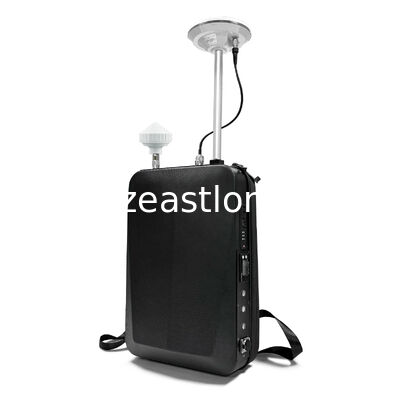
6 Channels 3000m GPS Spoofing System for Anti Drone UAV with Fake GPS Location and Super Jamming

Product Details
| Product Name | GPS Spoofer | Working Frequency | BDS, GPS, GNSS, GALIELO |
|---|---|---|---|
| Single Channel Output Power | 10W | Power Supply | AC 110-240V + Built-in Battery |
| Spoofing Range | 3000-5000 Meters | Working Mode | Fake Location, Circling Motion, Linear Motion, Super Jamming |
| Highlight | Cell Phone Signal Amplifier,GSM Signal Repeater |
||
Product Description
3000M GPS Spoofing System
1. Main Functions
1.1 With generative deception interference, real time calculation of necessary parameters such as GPS, BDS, GLONASS, Galileo signals that the target needs to receive at the device location, build corresponding mathematical simulation models and signal synthesis modules to generate real-time navigation satellite deception signals.
1.2 Capable of receiving and analyzing GPS, BDS, GLONASS, Galileo signals, and achieving time synchronization and ephemeris acquisition between satellite and ground.
1.3 One Click Defense (Crash Mode): by generating simulated navigation satellite signals, invading the drone's positioning and navigation module, forcing the drone to stall and crash.
1.4 Virtual Location: based on the current real positioning position, simulate a virtual coordinate position that deviates from 500m-1km to prevent the other party from detecting the real location through drone positioning, prevent smartphones from taking photos (with coordinates attached), send accurate positioning, and prevent close range reconnaissance from sending real coordinates.
1.5 With network communication interface, can be operated online with wireless direction finding device, radar, and etc. (supported by defense system software platform), to achieve automatic departure of unmanned aerial vehicles and fixed-point forced landing (capture) of unmanned aerial vehicles.
2. Main Features
2.1 With comprehensive defense and multi-target drone deception capabilities.
2.2 Blocking navigation of black flight drones, minimal impact on the surrounding environment.
2.3 Support network control and management for multi defense devices.
2.4 No need manual duty, 24 hours automatically defending against drones.
3. Technical Data
1. configured navigation satellite signals
Can simulate signals under GPS, BDS, GLONASS, Galileo, standard with 6 frequency points, and support with other systems and frequency point expansion.
| No. | Satellite System | Frequency Band | Center Frequency Point (MHz) | Bandwidth (MHz) | Channels |
| 1 | BDS | B1I | 1561.098 | ±2.046 | 12 |
| 2 | GPS | L1 C/A | 1575.42 | ±1.023 | 12 |
| 3 | GPS | L2 | 1227.6 | ±1.023 | 12 |
| 4 | GPS | L5 | 1176.45 | ±10.23 | 12 |
| 5 | GLONASS | L1 | 1602 | 1598.0625- 1605.375 | 12 |
| 6 | GALILEO | E1 | 1575.42 | ±12.276 | 12 |
Available Frequency Point for Expansion
| No. | Satellite System | Frequency Band | Working Frequency (MHz) | Modulation Type |
| 1 | GPS | L1 C/A | 1575.42 | BPSK |
| 2 | L2 C/A | 1227.6 | QPSK | |
| 3 | L5 | 1176.45 | QPSK | |
| 4 | BDS | B1-I | 1561.098 | BPSK |
| 5 | B1C | 1575.42 | QMBOC | |
| 6 | B2-I | 1207.14 | BPSK | |
| 7 | B3I | 1268.52 | BPSK | |
| 8 | GLONASS | R1 | 1598-1605 | BPSK |
| 9 | R2 | 1242-1251 | BPSK | |
| 10 | GALILEO | E1 | 1575.42 | CBOC |
3. Parameter
3.1 Input: AC 220V 50Hz
3.2 Working Temperature: -40℃~+70℃
3.3 Storage Temperature: -45℃~+80℃
3.4 Power supply, network port, RF lightning protection: 1.2/50us&8/20us, differential mode 2kV (2Ω), common mode 4kV (12Ω)
3.5 Complies with IEC61000-4-5
3.6 Protection Level: IP65
3.7 Dimension / Weight: approx. 295mm×510mm×80mm (fixing use) / ≤7KG
approx. 355mm×295mm×150mm (backpack case) / ≤7KG
approx. 550 x 355 x 235 mm (big portable luggage case) / ≤15KG
4. full kit including: main unit x 1pc, antenna x 1set (transmitting and receiving), connection cables x 1set
4. Using Guide
In both outdoor and indoor settings, please check the user manual carefully, connect all correctly, and set the system properly.
4.1 Put the transmitting antenna in open area to ensure the coverage without any shielding.
4.2 Place the mushroom head of receiving antenna facing the sky, with no obstructions around, to enhance the effectiveness of satellite signals receiving.
Note: at least 1 meter between the transmitting antenna and receiving antenna to avoid interfere with each other.
4.3 Plug in and switch on the device after system setting, it will search for the satellite automatically in 5 minutes. Search completed, the system in standby mode.
5. Applications
5.1 Protection of domestic no-fly zones , such as politically sensitive areas, military management areas, national strategic resources projects, nuclear industrial facilities, airports, prisons, and border defense areas.
5.2 The site to prevent information leakage, such as: major security activities on-site, major criminal cases on-site, urban management law enforcement site, politicians accompanying protection, rehearsal of large-scale performances, important security venues, archaeological excavation site, large-scale group event scene.
5.3 Combat the use of drones as a carrier of illegal activities, such as: terrorist attacks, trafficking in smuggled drugs, illegal articles or information transmission.
Recommended Products